Only properly equipped climbers having experience of loose and vegetated sea cliffs should attempt this route. This is not a guide and does not contain tidal information required to pass many of the rock features along the route.
 Leaving Goat Rock at Foreland Point and moving west beneath the lighthouse.
 The strata tips west forming flooded gullies which may require a short jump.
 Many of the seaward running ridges are smooth.
 The Foreland Arch.
 The Gun Caverns. 700m west of the lighthouse.
 Inside the Gun Caverns.
 The ribs conceal the Gun Caverns. The beach is Sillery 3. The gullies, Coddow Slip and Great Red start here.
 Coddow Slip Gully
 Great Red Gully.
1. Coddow Slip Gully.
2.Great Red Gully.
3. Upper Blackhead Point.
4. Lower Blackhead Point.
5. Lynmouth.
 Low cliffs under The North Walk. Valley of Rocks.
 Hollerday Buttress and the concave Hollerday Wall. Conventional climbs here.
 Traversing the east wall of The East Inlet. 1978.
 Top of the west wall of The East Inlet. Hard.
 On the right day with the right tide and weather it is possibly to boulder hop across the entrance of The East Inlet if you are very lucky.
 Beneath The Valley of Rocks.
1. Hollerday Wall.
2. East Inlet.
3. Mother Meldrums Gut.
4. Dog Hole.
 1. Hollerday Buttress.
2. East Inlet.
3. Mother Meldrums Gut.
4. Yellowstone Ridge.
4. Yellowstone Ridge.
 Yellowstone Ridge.
 1. Hollerday Buttress.
2.Yellowstone Arete. HS.
3. East Inlet.
4. Yellowstone Ridge.
5. Mother Meldrums Gut.

1. East Inlet.
2. Yellowstone Ridge.
3. Mother Meldrums Gut.
4. Traverse line.
 Leaving Mother Meldrums Gut towards Dog Hole.
 Dog Hole.
 Duty Point looking back at:
1. Dog Hole.
2. Castle Rock. Dirty Epic. XS.
3. Wringcliff Bay.
4. Chimney Sweep route.
 Duty Creek. 1978.
 Duty Creek. 1978.
 Duty Creek in recent times.
 Starting the Duty Creek traverse.
 Duty Creek traverse.
 Duty Point looking towards:
1. Crock Point.
2. Woody Bay.
3. Wringapeak.
3. Wringapeak.
 Lee Bay.
1. Crock Point.
 Lee Bay from Crock Point.
 Crock Point.
 Crock Point.
 Crock Point.
 Crock Point. West side. 1990's.
 Woody Bay hanging waterfall. 1978.
 Woody Bay Beach.
 Wringapeak.
1. Through cave.
2. Highveer Point.
 1. Wringapeak through cave.
 Wringapeak Cave.
1. Big Bluff.
 Wringapeak. West side.
 The Inner Sanctuary.
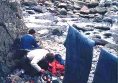
 The second camp at Big Bluff. 1978.
 1. Big Bluff cave entrance.
 1. Big Bluff.
 1. Big Bluff.
 1. Double Bluff.
 Big Bluff.
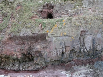
 1. Foreland Point.
 1. The A Cave.
 The A Cave.
 The A Cave.
 A Cave traverse.
 1. The A Cave.
2. Pharoahs Chimney HVS.
 1. Black Wall.
 The Inner Sanctuary.
 The Corridor Route. Under The Flying Buttress.
 The traverse of The Claw. 1978.
 Cyril Manning. One of the early pioneers.
 The Claw.
 Hanningtons Cave.
 1. Highveer Point.
 Heddons Mouth 1978. Third camp.
 1. Pimple Rock.
 Heddons Mouth.
 West of Heddons Mouth.
 The Tuesday Route.
 1. The Coxcombe.
 The Coxcombe Ridge.
 The Swim.
 The Swim.
 Moving west from The Swim traverse.
 The Coxcombe. West side.
 Bosley Gut.
 Climbing into North Cleave Gut.
 North Cleave Gut.
 North Cleave Gut.
 Cathedral Cave.
 The Impressive Pillar.
 Neckwood Gut.
 1. North Cleave Gut.
 Notch Gully.
 Holelake Cave.
 Holelake Waterfall.
 Just west of Holelake Waterfall.
 1. Holelake Cave.
 The Mare and Colt offshore pinnacles.
 Sherrycombe Waterfall.

 Sherrycombe towards Great Hangman Gut.
 Blackstone Beach just west of Gt Hangman Gut.

 Leaving Gt Hangman Gut across the bottom of The West Ridge Route towards Blackstone Beach.
 Miners Gully. 500m west of Gt Hangman Gut.
 Mine adit. Blacstone Beach.
 Mine adit. Blackstone Beach.
 Yes Tor. Great gritstone climbing.
 Yes Tor.
 Yes Tor.


 The Scotch Stone Reef. Little Hangman.
 Another Cathedral Cave. Turning the corner towards Wildpear Beach.
 Stepping Stones Cave. Nr Wildpear Beach.
 Stepping Stones Cave Inlet.

 The Hangmans towards Heddons Mouth in winter.
 Wringapeak. West side.
 The Inner Sanctuary.
 The second camp at Big Bluff. 1978.
 1. Big Bluff cave entrance.
2. Big Bluff.
3. Double Bluff.
4. Great Bastion.
 1. Big Bluff.
2. Double Bluff.
3. Great Bastion.
4. Cormorant Rock.
5. Hollowbrook.
 1. Big Bluff.
2. Double Bluff Cave.
3. Great Bastion.
4. Stile on the Goat Track.
 1. Double Bluff.
2. Great Bastion.
3. The Yogi Hole.
4. Hollowbrook Waterfall.
4. Hollowbrook Waterfall.
Note the high water stain.
 Big Bluff.
 1. Foreland Point.
2. Castle Rock. Valley of Rocks.
3. Wringapeak.
 Big Bluff.
 Great Bastion.
 The Yogi Hole. Great Bastion.
 The Yogi Hole.
 Leaving The Yogi Hole.
 Great Bastion. West side.
 Cormorant Rock.
 Cormorant Rock.
 Hollowbrook Waterfall.
 1. The Black Wall. 200m west of Hollowbrook. Hard.
 The Black Wall.
 Big Bluff.
 Great Bastion.
 The Yogi Hole. Great Bastion.
 The Yogi Hole.
 Leaving The Yogi Hole.
 Great Bastion. West side.
 Cormorant Rock.
 Cormorant Rock.
 Hollowbrook Waterfall.
 1. The Black Wall. 200m west of Hollowbrook. Hard.
 The Black Wall.
 1. The A Cave.
2. Red Slide Buttress.
3.
4. Kittiwake Slab.
 The A Cave.
 The A Cave.
 A Cave traverse.
 1. The A Cave.
2. Pharoahs Chimney HVS.
 1. Black Wall.
2. The A Cave.
3. Red Slide Buttress.
4. Kittiwake Slab.
5. The Flying Buttress.
6. The Claw.
 The Inner Sanctuary.
 The Corridor Route. Under The Flying Buttress.
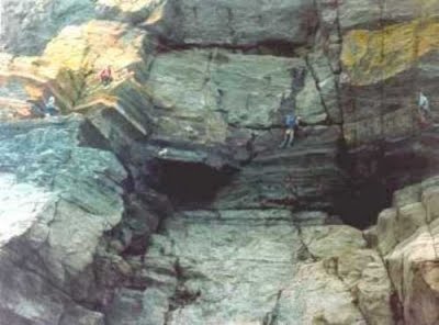 The traverse of The Claw. 1978.
 Cyril Manning. One of the early pioneers.
 The Claw.
 Hanningtons Cave.
 1. Highveer Point.
2. Heddons Mouth.
3. Pimple Rock.
 Heddons Mouth 1978. Third camp.
 1. Pimple Rock.
 Heddons Mouth.
 West of Heddons Mouth.
 The Tuesday Route.
 1. The Coxcombe.
2. The Swim.
3. Bosley Gut.
 The Coxcombe Ridge.
 The Swim.
 The Swim.
 Moving west from The Swim traverse.
 The Coxcombe. West side.
 Bosley Gut.
 Climbing into North Cleave Gut.
 North Cleave Gut.
 North Cleave Gut.
 Cathedral Cave.
 The Impressive Pillar.
 Neckwood Gut.
 1. North Cleave Gut.
2. Cathedral Cave.
3. The Impressive Pillar.
4. Neckwood Gut.
5. Neckwood.
 Notch Gully.
 Holelake Cave.
 Holelake Waterfall.
 Just west of Holelake Waterfall.
 1. Holelake Cave.
2. Holelake Waterfall.
3. The Mare and Colt pinnacles.
 The Mare and Colt offshore pinnacles.
 Sherrycombe Waterfall.
Difficult section 200m west of Sherrycombe.
Sherrycombe towards Great Hangman Gut. Blackstone Beach just west of Gt Hangman Gut.
Great Hangman Gut.
Leaving Gt Hangman Gut across the bottom of The West Ridge Route towards Blackstone Beach. Miners Gully. 500m west of Gt Hangman Gut.
 Mine adit. Blacstone Beach.
 Mine adit. Blackstone Beach. Yes Tor. Great gritstone climbing. Yes Tor. Yes Tor.
Yes Tor.
Little Hangman Gut.
Little Hangman Gut.
Little hangman Cliffs with the large East / West cave and Ramp.
1. Fossil Cliff.
2. Gritstone climbing area. See guidebook.
3. East West cave.
4. Scotch Stone.
Vertical and wet seaward wall of The Ramp. 1978.
The Ramp in summer.
The Ramp.
The East/West cave and Ramp.
The Black Chimney. 100m west of East/West cave.
The Scotch Stone Reef. Little Hangman. Another Cathedral Cave. Turning the corner towards Wildpear Beach. Stepping Stones Cave. Nr Wildpear Beach. Stepping Stones Cave Inlet. Stepping Stones Cave.
The Hangmans towards Heddons Mouth in winter.
8 comments:
Is there a guide to this route?
There was a private publication ‘Coastal Climbs in North Devon’ by C.H. Archer during the 1960’s. Its quite detailed in describing features along the route but lacking in detail of how to climb across those features. He appears to have swam by the difficult sections, but he was climbing in nails. Conversely the escape routes he describes on vertical vegetation would have seemed standard stuff to him but hell on earth to the modern climber wearing rubber soles. I do not know where you could find a copy nowadays.
HIDDEN EDGE OF EXMOOR SHOWS BY KESTER WEBB 2010 – 2011
VALLEY OF ROCKS: Illustrated with landscape paintings by artists from the Pre-Raphaelites to the present day and by aerial photography, this exploration of the dry valley, sea-cliffs and caves below North Walk, with rock-climbing, provides an in depth study of the geological evolution of this extraordinary part of the North Devon landscape.
VALLEY OF ROCKS: Watchet Methodist Hall. 8th Dec 2010.
VALLEY OF ROCKS: Porlock Village Hall. 19th Jan 2011.
ALL SHOWS begin at 7.30pm.
Details: Kester or Liz Tel 01271 850349. Email e.f.webb@btinternet.com
I came across this the other day. Pretty basic info but gives an indication of locations plus grid references, parking and access. Pages 11 to 18 are relevent to the exmoor coast.
Coastal Climbs
Tonight at 7pm BBC2 West. Coast. Nick Crane climbing at Foreland Point.
Anyone know if the waterfalls are frozen?
Anyone got a list of suitable tides for 2011?
The weekend of 22nd / 23rd January looks good, weather permitting
Post a Comment